 Sign In
 0 Items (
 Search


 “It was the nearest run thing you ever saw in your life,” said the Duke of Wellington about his last-minute victory in the Battle of Waterloo in 1815, which ended the Napoleonic Wars and left Britain the greatest power in Europe for the rest of the nineteenth century. While anyone educated in Australia has at least heard about Waterloo, there was another near-run thing not long after another defeat of France by Britain in 1763 that ended the Seven Years War. It is one that is hardly known today and never publicly discussed. However, this other thing was a critical step in the founding of the Australian colonies, and eventually the Australian nation.
In October 1766, in the wake of France’s loss to Britain of most of its colonies in North America, Louis XV gave Captain Louis Bougainville orders for an expedition to explore the Pacific Ocean. He was to examine the “lands sighted by navigators and called Diemen Land, New Holland, Carpentaria, Land of the Holy Spirit, New Guinea etc” and, most importantly, “as soon as Mr Bougainville lands in unknown places, he will see to it that posts bearing the arms of France are erected and draw up Acts of Possession in the name of His Majesty”. The orders continued:
The area Mr Bougainville must concentrate on examining is especially the one stretching from the fortieth degrees of southern latitude towards the north … He will note as far as possible all the places that could serve as ports of call for ships and everything relating to navigation.
The fortieth latitude runs right through the middle of Bass Strait, and the lands north of that are the southern and eastern coasts of Australia. In other words, French strategy had turned its attention to the resources and naval sites of what turned out to be the richest part of the Australian continent. Bougainville’s orders were to make these “unknown places” the possession of the French king.
This column appears in the latest Quadrant
In the century before Bougainville set out, some thirty Dutch explorers had charted the western and northern coasts of the continent they called New Holland, from the southern coastline of Van Diemen’s Land to the Gulf of Carpentaria, as far as the western tip of Cape York. However, the Dutch never made the final act of possession by landing a garrison there. So, under international law and diplomatic practice at the time, the whole continent was still open to a power that explored and charted its territory and declared itself sovereign.
Bougainville actually got within very close range of doing that. He rounded Cape Horn and then headed westwards across the Pacific to his principal goal: “I persevered in keeping in the parallel of 15 degrees … because I wanted to verify our conjectures by getting sight of the eastern coasts of New Holland.” On June 4, 1768, almost due east of present-day Cooktown, the first signs of the east coast of the Australian mainland came into view.
Immediately ahead of him, Bougainville could see surf breaking over some of the outlying parts of the Great Barrier Reef. “The sea broke with great violence on these shoals,” he later wrote, “and some summits of rocks appeared above water from space to space.” When he came across the coral-crusted tip of an ancient volcano now known as Bougainville Reef, he changed his mind about trying to reach the mainland. Instead of obeying his orders and heading south to Van Diemen’s Land, and finding one of the many reef-free harbours on more southerly shores, Bougainville decided to sail north around the far side of New Guinea and head for Batavia, the Dutch colony on Java, and then return to France after circumnavigating the globe.
It was not until two years later that James Cook on the Endeavour was faced with a similar problem. After he finished circumnavigating the islands of New Zealand in March 1770, Cook contemplated taking the fast way home, using the winds of the Roaring Forties to take him east, past Cape Horn to Cape Town, and then up the coast of Africa to England. However, he decided instead to explore the uncharted east coast of New Holland and to go home via the Torres Strait and Batavia.
Cook found the Australian mainland near the mouth of Bass Strait on April 19, 1770. From then until August he sailed and charted the entire east coast up to Cape York. Despite the barrier reef’s near fatal holing of his ship in June, laying it up ashore for repairs that took six weeks, Cook completed his self-appointed task and then he too set sail for home.
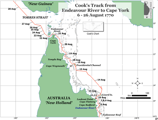
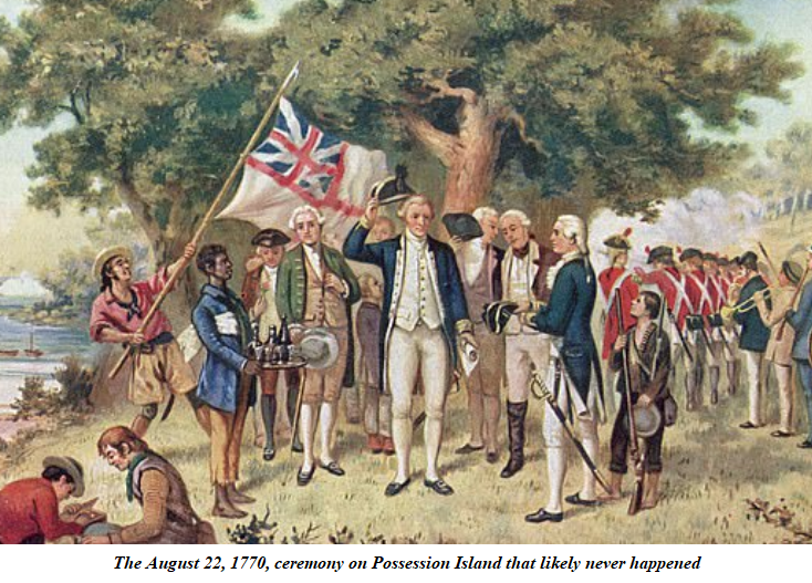
His journal records that on August 22, 1770, while searching for a channel through the cluster of islands around the cape, Cook went ashore on one island with a higher peak than the rest to survey his best way forward. He took botanists Joseph Banks and Daniel Solander and a marine with him. When they reached the top, Cook could see the channel he was looking for. He then raised a flag and the marine fired three shots into the air. The sailors on the ship cheered. According to Cook’s official journal, he then declared the entire coastline he had just charted as a possession of George III. He named the site of his ceremony Possession Island.
Now, as part of the commemoration of the 250th anniversary of Cook’s first voyage, the replica Endeavour has already done a re-enactment of the circumnavigation of both islands of New Zealand. It was due to start a circumnavigation of the Australian continent in April, but this was put off at the last minute because of the COVID-19 lockdown. It is still uncertain whether the journey will be just postponed or cancelled altogether. If all goes well in combatting the virus, one obvious alternative would be to do something commemorative on August 22, 2020, to mark the anniversary of Cook’s possession ceremony.
There is a problem, however, with what we believe about this ceremony. It probably never happened. This is the conclusion that Margaret Cameron-Ash draws in her book about Cook, Lying for the Admiralty (Rosenberg, 2018). This book remains the only truly original work on Cook published in Australia for the 250th anniversary. Fortunately, it is also among the best-researched works on Cook ever written. I reviewed it more fully in Quadrant in September 2018.
Cameron-Ash does some impressive detective work on what happened on Possession Island that day, and what Cook and his colleagues each wrote about it soon after. Only when he reached Batavia did Cook learn from the Dutch that Bougainville had been exploring the Pacific almost two years before he left England. Cook had never thought any European before himself had gone near the eastern coast of New Holland. He was struck by the awful possibility that Bougainville might very well have claimed the east coast for France and left a cairn or a marked tree to prove he had been there: a strategic coup in the European advance into the Pacific.
Cameron-Ash argues that Cook’s little ceremony on the Torres Strait island had nothing to do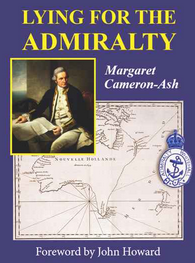 with possession. It would have been the wrong place to do it anyway, because that side of Cape York was, technically, Dutch territory. The flag raising and musket shots were simply signals from Cook to his ship that he had found the passage he was looking for. The sailors on the ship cheered because they then knew they could head home. None of the original diaries written on board by the botanists and other gentlemen mentioned a possession ceremony or even the name Possession Island. In fact, Cameron-Ash discovered one document showing that Banks had once called the site Passage Island, recording its original significance.
So in Batavia, Cook decided to shore up his accomplishment, and British sovereignty, by rewriting parts of his journal. He wrote a new version of a possession ceremony on another sheet of paper and inserted it into his journal.
Cook’s exploration of the eastern coast, and what fortunately turned out to be his uncontested claim to possession, was not just a great job by a skilled navigator, as the few favourable press stories about him today record. It was the key move in the grand strategic contest for domination in the Pacific. It was an essential step in making Britain the first truly global power. The liberal international economic order it fostered gave the world a century of peace in which technology and trade produced unparalleled innovation and prosperity. This would have been a far more limited outcome if a regime of French absolutism had gained naval domination of the Pacific in the late eighteenth century. Had Cook and Bougainville, faced with the perils of the Great Barrier Reef, not made the critical decisions they did, when they did, modern Australia would have been a very different place.
Keith Windschuttle is the editor of Quadrant


Cameron-Ash did a good job with the “possession” story. But I doubt if things would have been different if Bougainville had stayed on course and indulged in some possession theatrics on the Queensland coast. The game of competitive flag-planting and cairn-building was understood as an initial ploy, and only meant something for the future if the colonial power could follow up with naval power and settlers. The French were in no position to do that, mainly because the Royal Navy was uniformly too strong for them (except at the Chesapeake in 1781). Thus St Aloüarn’s taking possession of the still “vacant” Western Australia in 1772 remained just a meaningless stunt. The same with de Surville’s visit to New Zealand in 1769 – he didn’t make claims of possession, but if he had it wouldn’t have meant much.